
Weather: It was nice until I decided to go rowing. I didn’t go first thing in the morning since the tide was low. (It’s tough to launch at low tide because there are extensive sand flats all around the island. High tide was at 2:40pm. I launched about 12:45. As I walked over the dune to the beach, I noticed there was a bit more wind. It turns out it continued to freshen through the row. It turned out to be quite an adventure.


I turned north and headed up to Wellfleet Harbor. I actually headed somewhat NW, into the wind and waves until I was past the north point of the island. Then I headed more northeasterly with the wind and waves on my stern quarter. It was only 500m or so, but it felt longer in the boat. Then I lined up a course to take me to the end of the wellfleet harbor breakwater. The wind felt like it was on my port bow quarter, and this was actually a reasonable course with the building waves. At this point they were probably 12″ or so and quite unpredictable. I’d get a couple big ones, and then a few minutes with much smaller ones. I enjoyed this part of the row a lot, but not as much as when I turned the corner after the breakwater. I turned east. The wind was close to dead astern, and the breakwater took care of the chop. There was a longer period swell that seemed to bend around the end of the breakwater and I was surfing down the face of these waves. This was a blast.
It all came to an end when I turned around at the east end of the harbor. All of the sudden the wind that was diminished by me going in the same direction, was right on the bow. Going into the harbor, I was rowing 2:30-2:40 splits, coming back out, I was lucky to get below 3:30. Even on smooth water, this was hard work. As I came out past the end of the breakwater, and hit the waves that built up across the broad fetch over to the great split, it got even rougher. My original thought had been to cross over to Chequesset Neck and then row down the great spit, which would have been somewhat sheltered from the waves, then I would cross back over to the island at the south end of the spit. That plan did not last too long. I bashed my way against the waves and the wind for a few minutes and then decided that I had had enough. I turned for home and tried to navigate with the waves a little bit forward of my beam.
This was easier, but still a lot of work. I would go through sections where the water was reasonably flat and I would get some good strokes in, then I would slam into some bigger waves and completely fill the cockpit with water. The bailer couldn’t keep pace with the all the water that was coming in. At this point the waves were 12 to 18″ and I was struggling with the conditions. The worst was the last 1000m. This part was over the shallow Lt Island shoal that extends out from the island. The waves were much bigger here and most of them were breaking. I just tried to pick my way through them. You can see my HR went down a lot in this section.
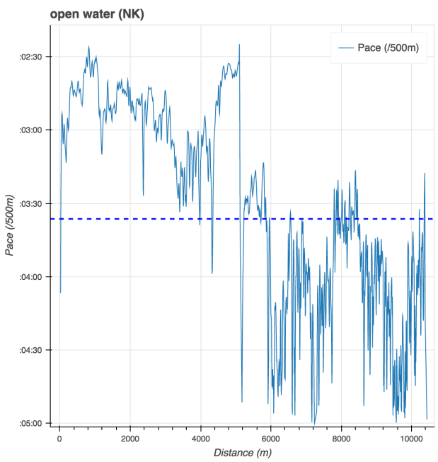
You can’t really see just how slow I was going when I turned around into the waves on the summary chart.

So, here it is in isolation.
I am trying to construct what happened when. I used Google earth, which can show telemetry along the mapped route to figure it out.
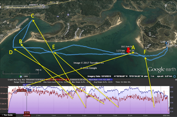
A. Decide to head straight up to Wellfleet instead of heading over to Indian neck since the waves were building.
B. Turn behind the breakwater. The next chunk was fun.
C. Turn around to row back into the wind.
D. Get slammed around enough that I decide to head straight home instead of heading for Great Spit.
E. Huge waves stop me dead and fill up the whole cockpit, even the seat deck was under water. Noticed that the self bailer was a bit fouled, cleaned it out and continued.
F. Get to the shoals around the island and the waves start breaking. Pick my way between them back to the beach.
Even though it was hard work, and frankly a little scary at times, I enjoyed it and I think it provided some useful rough water practice. I feel pretty confident about what the boat will do in these circumstances and I’m getting the hang of working with the waves.
It was also a pretty good workout.

I noticed a couple of interesting quirks in the telemetry.
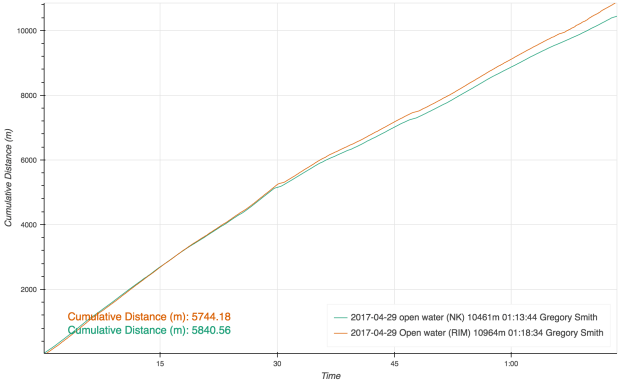
First, the algorithm that NK is using to detect strokes doesn’t work as well as RIM when you are going slowly and getting slammed by big waves. In the comparison plot below the RIM data is blue and the NK data is red. The total stroke count on the NK was way off too. I was counting strokes and NK was over counting by about 5 strokes per hundred.

Second, there is a mismatch in total logged distance. In the first half of the row, with less wave action, they match up well, but as soon as I was pounding into the waves, RIM started to give me credit for more distance than NK. One idea is that RIM might be measuring distance in 3 dimensions and NK is measuring in 2? But by the end, it was a difference of about 500m
When I got back to the beach, enough water had leaked into the bow of the boat that I could not lift it. I had to flip it over and let it drain for 5 minutes before I could carry it to the car. I think I found where the leak is. There is a crack in the bulkhead between the seat deck and the cockpit bottom. Whenever the cockpit gets full, water can drain into the bow. Since the cockpit was basically full the second half of the outing, the boat must have been half swamped by the time I was back to the island. No wonder it felt so sluggish.
Next weekend, I think I need to do some fiberglass work!
