
Weather: I launched right around 8am. There was a little wind that was dying down.
The more salient bit of data was the tides. We are in a period of time called the King Tides. These occur a few times a year when the moon is at perigee and also aligned with the sun (new moon of full moon). If they happen around January 2nd, they are even bigger because the earth is at perihelion. These tides were pretty damn big.
Here’s a view of the Lieutenant Island Tide calendar.

The squiggle is the tide height. The numbers above each peak is the time and height of the high tide. The highest tide of the month was very early Saturday morning (12:46AM May 27th) and was a 13.0 tide.
Aside: The faint line near the high tide points is the tide height where the water comes over the road to the island. When these tides are very high, you are cut off for about 4 hours around high tide.
The low tides are correspondingly low. I launch from a beach that has the best low tide access, but this particular low tide ended up causing me a comic 30 minutes of trying to find deep enough water to row in.
Here it is speeded up buy a factor of 30 to reduce the boredom factor.
Certainly an inauspicious was to start.
Once I got through that, I was able to really try out the new boat. Here’s my course.

This chart was made with some a navigation. A program called GPSNavX which supports plotting course directly on navigation charts. The GPS coordinates come from the speedcoach, exported to CSV using NK Link, then uploaded to rowsandall, then exported as TCX, then convert to GPX by TCXConverter, then loaded into GPSNavX. Simple 😉
This part was “on foot”
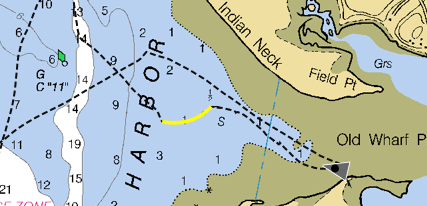
The row up to Wellfleet was good fun. There was some light wind was from the SSW, so the chop could build up more as I got further north. The boat handles quartering waves very well and surfing directly downwind is rock solid and good fun.
I noticed that there were patches of floating reeds all over the place. These float out of the salt marshes during very high tides. They had the effect of turning this outing into something like a random bungee row. I would be rowing along, pass through an area with some reeds and eventually notice that it was harder to keep the pace. Then, I would stop, back the boat down, wiggle it a bit from side to side and see a big clump of reeds float up from the fin.
I turned and headed out to sea. The wind basically stopped and there was very little chop. I just tried to set a nice rhythm and take long easy strokes. My HR monitor decided early in the row that it didn’t want to cooperate, so I didn’t have that feedback. My guess is that most of the row was low UT1.
I passed over Smalley Bar, and I noticed the water got appreciably lighter as it got shallower. At the shallowest, I could see the features on the bottom, but at least I didn’t need to get out and walk.
After that I noticed that my pace was getting mighty slow. It eventually dawned on me that the tide had turned and was now coming in. On the chart, you can see that I was in the deepest part of the channel for a while.
I got to Red Nun “6”, and decided to do another 2K to the south. That would put me at about 20km for the whole outing. The row to Green Can “5” was very slow because of the tide and I could see it flowing past.
Rowing into the tide, I was doing around a 3:30 pace. After I turned, with the same effort, I was doing around 2:20. I calculated out the current.

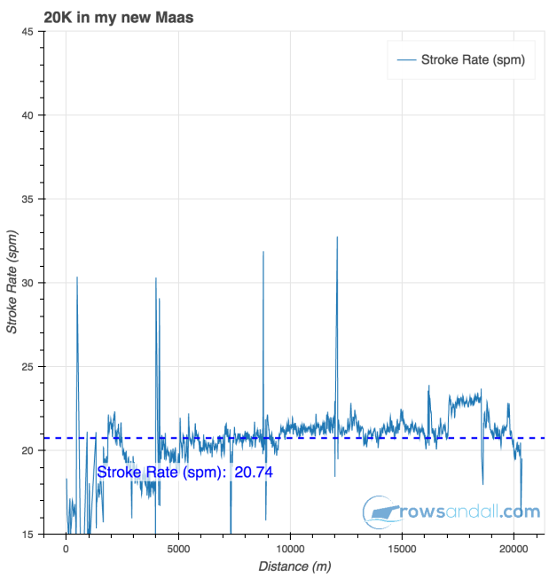
Here’s the pace and rate for the outing. The first 1000m were paddling, dragging and walking the boat.

Here’s a quick video showing a bit of the downwind with the waves, then me trying to row past the green buoy against the tide, and finally showing the process of getting the reeds off the fin.
Despite the initial challenges, I declare the voyage a success. The boat is amazing. It’s noticeably lighter to carry and much stiffer to row. I can’t say much about how it does in bigger waves, but I suspect it will do better than the Alden.
Anybody want a “slightly used” Alden Star?

You could have exported to Strava, then downloaded the GPX directly from there. Do you think there is a need for a GPX export from rowsandall.com?
The first video was hilarious. I especially liked the bit where the boat was left alone and you were far away. Such drama!
The second one doesn’t show up (yet).
LikeLike
I pushed save before I pasted the link. I’ve updated it now. I didn’t think to try to Strava export. That would have saved a step. A GPX export from rowsandall would be useful, but the extra step isn’t a real issue either.
I just got an app that should allow me to follow the track live on the chart on my phone, but I didn’t quite get it working right on this outing. Needs a little more experimentation.
LikeLiked by 1 person
Your thoughts on the conventional vs wing rigger version?
LikeLike
I could pretend to be more sophisticated than I am, but the reason I bought the one I did was because it was the boat that Dana had in stock for immediate delivery. The setup is incredibly stiff, but if I ever need to remove the riggers, it’s a pretty major task. So, if storability is important, the winged version would be a big plus.
LikeLiked by 1 person